With the addition of the one of the most comprehensive weather mobile applications around, the iAngler family of apps now provides even more information to users, whether on the water or maybe just thinking about going.
 All of the iAngler apps, including iAngler Tournament and MyFishCount, have a weather button that can be accessed without the need to start a trip. Pressing the button one time will give the user the weather conditions in their current location. Included in that report is information such as high and low temperature for the day, heat index and chance of precipitation. Scrolling down will show moon phases for the day and then an hourly forecast with predicted temperatures, rainfall and winds.
“The addition of the weather to the apps easily makes iAngler not only the most complete electronic fishing log book, but also one of the most valuable tools for either planning a trip on the water or knowing when it’s time to get back to the dock,” said the Angler Action Foundation’s Brett Fitzgerald. “With one click you can see tides, weather and wind and get an idea whether or not the fishing conditions will be to your liking.”
There are four tabs to the weather button in addition to the “Current” tab which serves as the landing place when you open the weather portion of the app.
“Forecast” displays the temperatures and expected conditions for the next seven days, breaking the forecast into a “Day” and “Night” tab. Touching each tab will open a drop down menu with a more detailed forecast.
The “Marine” tab gives current and future tidal projections for select areas, letting the user see clearly when the next high or low tide will be, based on their area. Below that is a marine report for a stretch of coastline out to 20 nautical miles with a drop down menu with detailed predictions for the next several days.
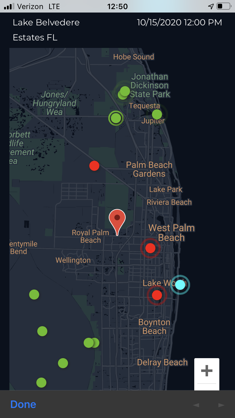
“Realtime” uses AIS data to display ships offshore and stationary inshore beacons, all of which display current conditions when selected. These beacons are shown on a real map and spread throughout the state.
The final tab is “Maps” which, when selected, offers five different maps to choose from. The Radar View is a current weather radar which can be activated to drag and zoom in to see the precipitation for a certain area. Surface Analysis shows the satellite view of pressure across the United States. Predictions shows the current national forecast with pressure and rainfall details. Near Future Forecast is an animated future forecast that shows the pressure and precipitation for the next 48 hours. And, final, the Weekly Forecast shows an animated version of the national forecast for the next week.
“The whole idea behind iAngler was to provide a service to anglers beyond the logging of fish, which is essential to the protection of our marine habitats,” Fitzgerald said. “The Weather button goes far and above anything I had ever hoped for when it came to giving anglers information they could use when they are either fishing or thinking about going fishing. For that matter, you don’t even have to be a fisherman to enjoy and learn from this newest feature.”
The iAngler family of apps can be found in the Google Play and Apple Store.
Want to help conserve fish stocks, habitats, and angler access? Join or donate. Every member, every volunteer and every penny helps.